

Whether you are just passing through or making a special trip out to Gunnison, CO, you should definitely check out Black Canyon National Park. First, you will want to stop into the visitor center to grab a map and pick up any backcountry permits you might need.
This post may contain affiliate links. Disclosure policy.
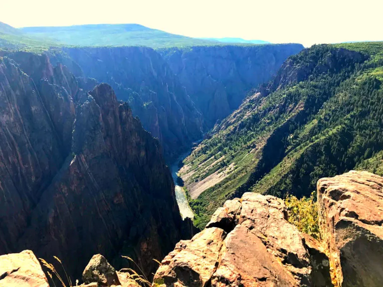
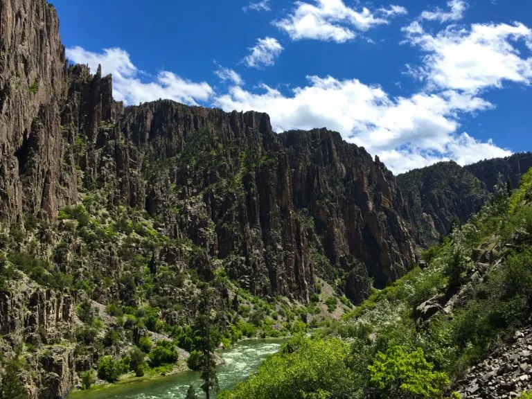
Gunnison Point
If you are just hanging around Black Canyon National Park for the day or not into hiking, we suggest picking up a map and driving along the scenic road. There are many stops along the route that require a short walk to the end of the canyon. And the very first scenic stop is right behind the visitor center. Gunnison Point is a short .2 miles and the first view down the canyon, showcasing the stunning turquoise Gunnison River running through the striated canyon walls. (Pictured above)
If you have time you can stop at each hiking trail, if you are short on time, pick a few that peak your interest. I’m going to share some of our favorites that we stopped at.
Pulpit Rock

Pulpit rock is the first stop after the Black Canyon National Park visitor center. The hike is 134 yards to the overlook. This overlook gives you a different angle seeing down the canyon walls.
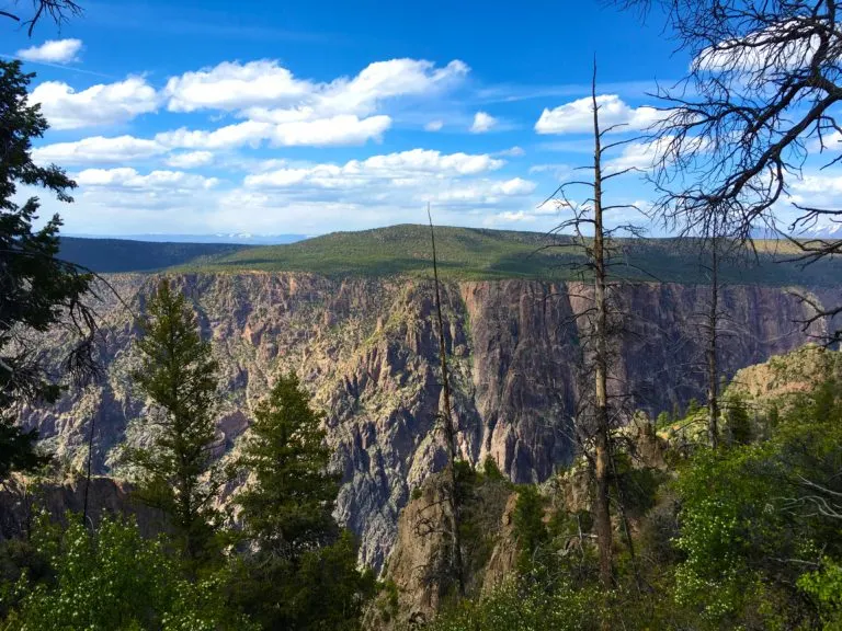
Painted Wall


Painted Wall (above) is the highest cliff in Colorado. It stands 2250 feet tall. In comparison to the Empire State Building which is 1250 feet tall, it’s almost double the height.
Sunset View:

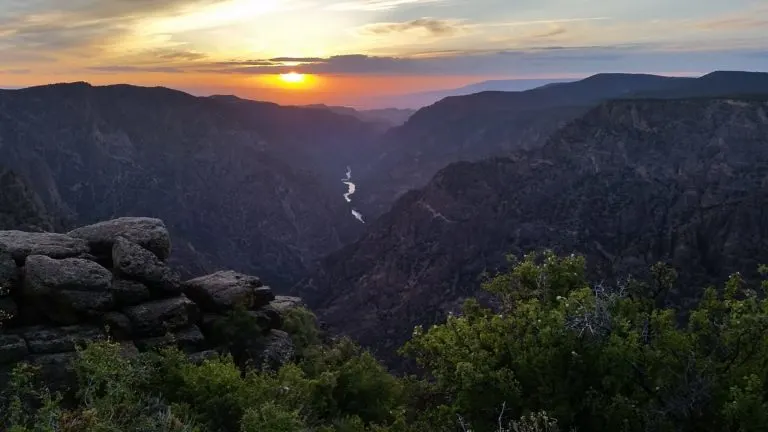
Sunset View hike is the prime spot to view the sunset in Black Canyon National Park because the sun sets right in line with the canyon. We were staying at the south rim campground and drove over there right before sunset. But be sure to add this sunset hike to your Black Canyon In Weekend Itinerary.
Warner Point:


We wanted to get some exercise so we stopped at warner point which is 1.5 miles out and back. We packed our backpacks and a little snack and had a nice cruise to warner point..
If you are staying for a weekend or longer, we suggest going down inside the canyon. A “Wilderness Use” permit is required to explore the inner canyon. You can get a free permit at the visitor center, but they are on a first come first serve basis (so be sure to arrive early).
Jake and I chose Gunnison Route which is the most popular and known to be the “easiest” inner canyon hike (it’s actually quite difficult). We decided to make it an overnight backpacking trip instead of making it a very strenuous day-hike (most people day-hike). There are only 3 campsites at the bottom of this hike, so permits for overnight camping are sometimes harder to get depending on the time of year.
Gunnison Route:

Hiking Stats For Backpacking Gunnison Route:
- Distance: 2 miles
- Elevation: 1800 feet
- Difficulty: Hard
- Type: Out and Back
- Permit: Required
- Bathroom: Visitor center at top & drop toilet at bottom
- Dogs: No
The Gunnison Route is 1 mile one way with an 1800 foot elevation change. The hike takes about 1.5+ hours for the descent. The hike starts at oak flat trail located right behind the South Rim Visitor Center.
Beginning Of Hike:
The beginning of the trail is very easy, walking down switchbacks through the forest. Then, about ⅓ miles in you will approach a sign that says “river access-permit required”. This is where the route gets a little trickier.
The Chain:
The trail will get a lot steeper and you will approach a chain that will help you down the trail (drainage). The chain is very helpful at this part because some rocks are very far apart and slipping is very easy to do. Along the rest of the trail there are rocks that resemble steps but be very cautious as some rocks are very wobbly.
Continuing On:
Once you get further along the trail you will start to see a large rock pile that you will need to scramble down to get to the river. Again, be very cautious as you don’t want to roll an ankle because help is pretty far away at this point and it’s a long ways up.
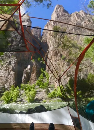
Finding The Campsites:
Once you reach the river you will notice 3 loosely marked campsites and there is an outhouse located downstream a few hundred feet away.

Warning:
It is suggested to take 4 quarts of water per person per day for this hike and also to bring high energy food (you can filter water from the river at the bottom). The current is strong so be careful to stay away from the edge and wading in the river is very dangerous (NOT suggested). The park rangers at the visitor center said the river can rise or fall without their notice, so you might want to set up your tent further from the river if possible.
There has also been traces of poison ivy near the river so be careful roaming around. There are no campfires allowed at the campsites, so be sure to have a different heat source for food if you choose to cook a hot meal.
Wildlife:
There is wildlife around, we encountered a couple deer (which scared the crap out of us at first), but they have also spotted bear occasionally. You will want to be careful about leaving food and backpacks unattended. They already have a bear-hang set up, so when you are done with your food/scented items for the night make sure to hang it so no critters/wildlife get into it.
Hiking Back Up:
The hike back up is the hard part because you are climbing back up 1800 feet of elevation. We also had heavy packs, so our legs were beat after we climbed back up. It’s only a mile back up to the top but it takes about 2+ hours to climb and it’s quite strenuous.
You will be climbing back up the scramble until you locate the trail. Again be careful and take your time because rescue is difficult on such steep terrain. When you get back up to the trailhead, you are required to go back and show your permit. This is to keep track of people out in the wilderness and to makes sure you made it back okay.

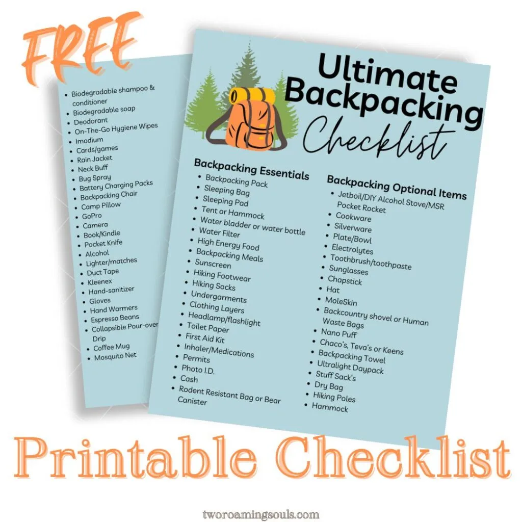
Grab our Backpacking Checklist
Takeaway | Black Canyon National Park In A Weekend
Know your fitness level before doing this hike because it is difficult and requires a good amount of physical endurance. We suggest backpacking because you get to explore the river and actually relax and enjoy the canyon from below. Bring high energy snacks and pack enough water!
If you don’t want to do a hike to the bottom, you can take a nice scenic drive down East Portal Road. But beware, the road is very steep with a lot of hairpin curves and 16-percent grade. Check within the visitor center to make sure your vehicle is allowed. There are a few nice spots to sit down by the river.


We hope you enjoy our itinerary for Black Canyon National Park In A Weekend!


The Ultimate 1 Week Colorado Road Trip - tworoamingsouls
Wednesday 11th of September 2019
[…] the way are Gunnison Point, Pulpit Rock, Painted Wall, and Sunset View. Check out our article: Black Canyon In A Weekend to get a better idea of the […]