
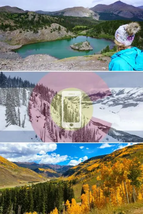
It’s no secret that Colorado has incredible opportunities for outdoor recreation. From hiking and biking, to skiing and snowboarding, Colorado is a great place for outdoor recreation. We love exploring all the beautiful nature in this state, and have found several essential outdoor recreation apps for Colorado adventures. They help us with choosing trails, checking snow reports, monitoring road conditions, or planning an epic Colorado road trip.

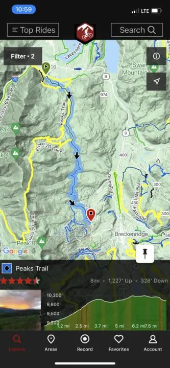
AllTrails App
The Alltrails App is our go-to resource for finding new trails. It provides distance, elevation, difficulty ratings, user ratings, trailhead info, photos, and more. Users can search, or explore with list or map view to find nearby trails. You can create lists of favorite trails to save for later or plan a trip. There are also helpful filters, so you can select hikes based on things like user rating, difficulty, activity types, attractions, family-friendliness, etc.
Alltrails also collects reviews from users, which can be really helpful for getting up-to-date trail details that can inform your preparation. Users share things like info about snow cover, sun exposure, downed trees, mosquito reports, or don’t miss that turn, ya know, anything they think might improve your experience.
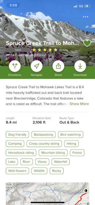
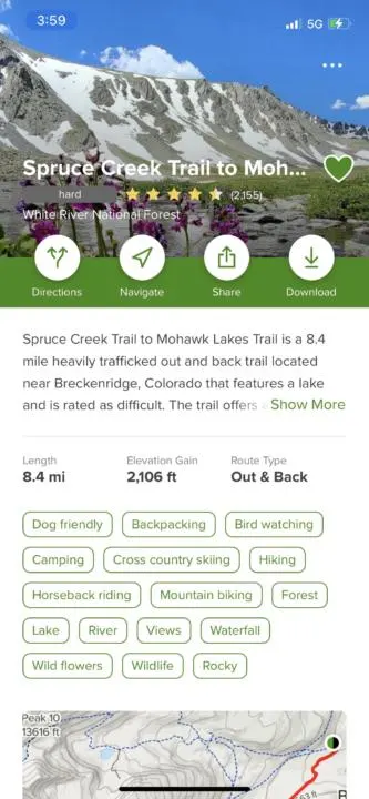
The other subtle thing we appreciate about Alltrails is that the photos are all user-submitted. So it’s generally photos taken by average people, which provides a fair representation of the trail and views. It’s a subtle but appreciated change from seeing highly edited photos on Instagram. Which set you up for being sorely disappointed that real-life doesn’t live up to the false promise.
Alltrails has a free version that is plenty for most users, but they also have a Pro subscription ($30/year) that provides extra perks like an ad-free interface and downloading maps for offline use. (Pro-Tip: free users can still download the trail map for offline use, it just doesn’t show topography or anything. But it’s still very helpful for getting back on trail if you stray off. Just make sure you save the trail to favorites and open the map view of the trail when you have service. It will be saved for later.)
Alltrails is best used for nature walks, hiking, backpacking, and mountain biking. But for the best biking resource, the next App is king.


MTB Project App
The MTB Project App is the most comprehensive app for finding mountain biking trails. This hyper-focused mountain biking app has loads of information about nearly any trail you could bike in Colorado. There are stats on trail difficulty, length, ascent, descent, user rating, etc.

Users can search using map view or list view, as well as filter trails by a variety of options. Then you can save any favorite trails you want to try or revisit.


Open Snow App
For all my fellow skiers and snowboarders, the Open Snow App is a must-have. They provide snowfall reports and forecasts to help you chase the powder. And there are typically regional forecast experts who provide write-ups to explain current and future storm systems, and how they may affect snowfall.
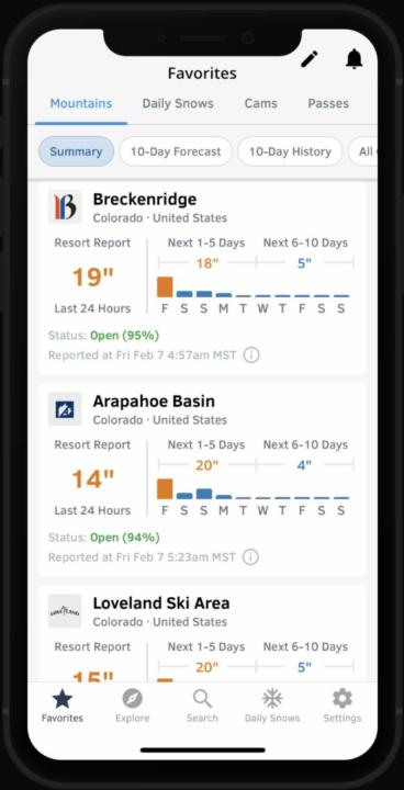
You can save your favorite ski resorts, so that your go-to mountains are easy to check quickly and easily. It can help you decide where to ski based on who got the most snow overnight, or over the past few days.
The free version provides forecasts up to 5 days ahead, which is plenty for most people. However, paid users ($30/year) get forecasts up to 10 days, plus live mountain cams, and other perks.


iOverlander App
The iOverlander App is a great resource for camping. It has tons of information about free and paid campsites, as well as locations of RV dump sites, propane refill, water, showers, laundry, wifi, and more.

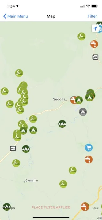
During our travels in our campervan, IOverlander is basically our most used app. The map view makes it really easy to find things nearby or plan ahead to our next destination. You can filter the app to only show you the things you are most interested in.
It also has reviews from users that can provide useful updates, like road conditions, cell service, nearby attractions, etc.
14ers App
For all my peak baggers, the 14ers App is a wonderful resource for planning and summiting many of Colorado’s highest peaks. For those who don’t know a “14er” is any mountain that’s taller than 14,000 feet, and Colorado has 58 of them. But the app even covers 13ers as well (mountains between 13k and 14k), of which there are 637 in Colorado. 13ers and 14ers are popular hiking and climbing destinations whose challenging routes and elevation provide unparalleled views and a great sense of accomplishment.
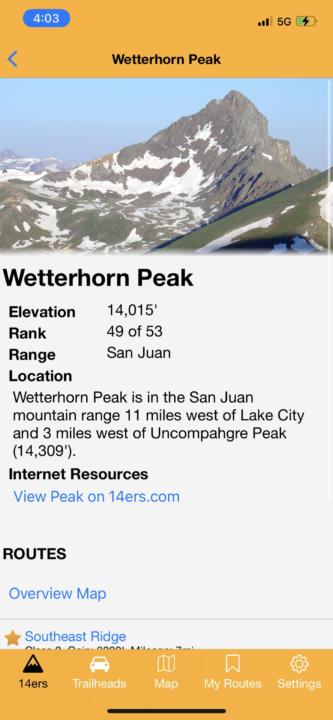

The 14ers App has a wealth of information from the easiest 14ers and 13ers to the most extreme climbing routes. You can see different trailheads and routes for each mountain. You can also read conditions updates from recent visitors.
Pro-Tip: 14ers have become quite popular in recent years (especially close to Denver), so opening up your options to include 13ers can provide you basically the same experience, with much fewer crowds. I promise, you won’t feel any less accomplished or challenged when climbing to 13,850 feet.


CDOT Colorado Road Conditions
None of these apps are any use if you can’t actually get to your destination. The CDOT Colorado Road Conditions App is a one-time purchase of $2.99, but worth every penny.
It’s an extremely valuable app for driving Colorado’s notoriously dangerous roads. Especially when you are driving in the mountains, a one-hour drive can quickly turn into a three-hour drive if the snow starts flying or there’s an accident. The CDOT Colorado Road Conditions can help get you to your destination safely and avoid traffic.
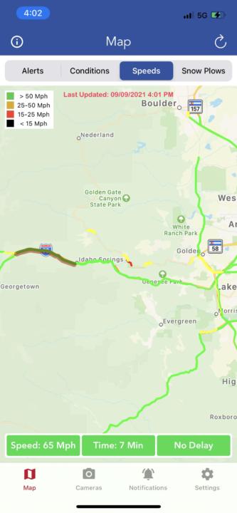

The CDOT app will make sure you always have the most up-to-date info about traffic, road conditions, construction, closures, and even snow plow routes.
You can also choose to receive notification alerts for specific stretches of road that are most important to you. For example, if you drive from Denver to Summit County to ski, or commute from Denver to Colorado Springs, you can receive alerts for those specific stretches of I-70 or I-25.
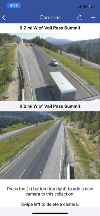
The CDOT Colorado Road Conditions app also has live cams, so you can look for yourself in real-time.
This app is so great for making sure you actually get to your destination to enjoy the outdoors.

Fire Weather & Avalanche Center
This one isn’t actually an app, but rather a website. But for information about wildfires, there is no better free resource than the Fire Weather & Avalanche Center. I have this webpage bookmarked and check it regularly during fire season.
There is tons of information about all known fires, seriously it’s probably more than your average person wants to know. But whether you are looking for at-a-glance info or want the in-depth details, the Fire Weather & Avalanche Center has it.
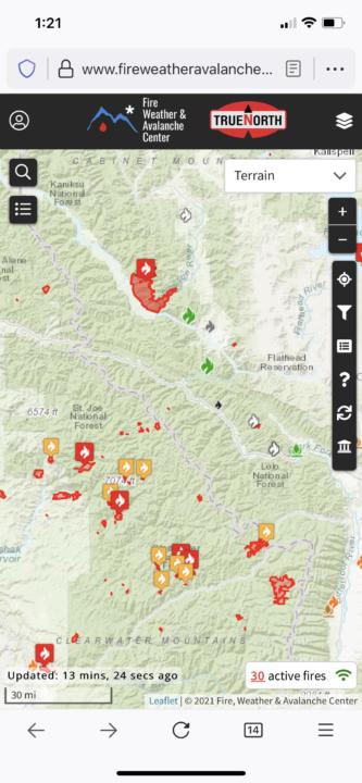
The default interface is a map view with color-coded fire icons. But from there, you can click on any fire to learn more about them. They cover everything from size, containment percentage, growth potential, and often even an incident write-up. There’s also information about who to contact to provide or receive additional information. For wildfire information, there is no better resource.


Weather Bug App
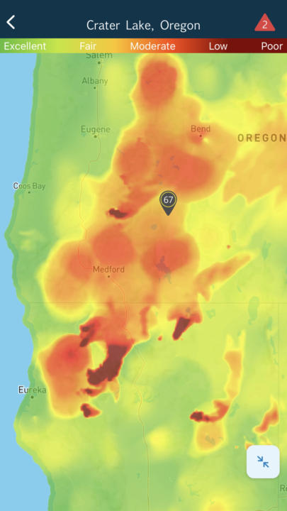
The Weather Bug App is pretty close to being our all-in-one weather app. It has a great interface that provides ALL its features for free. But probably my favorite thing about Weather Bug is the air quality and wildfire maps/alerts. We really appreciate the map view of air quality and wildfires. It helps us decide when and where to recreate outdoors.
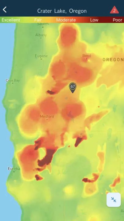
The lightning strike information is also useful for helping us avoid potential storms and decide when to seek shelter. Weather Bug also has some of the best pollen information available.
So when you include all the unique information plus typical weather forecasts and radar, the Weather Bug App is a must-have. Also check out our other favorite weather-specific apps.
Conclusion | Essential Outdoor Recreation Apps For Colorado
Next time you’re planning on getting outdoors in Colorado to enjoy your favorite activities, make sure you have the right information. We wanted to share the phone apps that we use all the time. These essential outdoor recreation apps for Colorado will make finding your next adventure even easier.
Help Share ‘Essential Outdoor Recreation Apps For Colorado’ On Pinterest!

Visiting Sky Ute Casino Resort | A Unique Vacation Escape in Southwestern Colorado - tworoamingsouls
Monday 3rd of October 2022
[…] Read: Essential Outdoor Recreation Apps For Colorado […]
How To Get From Denver To The Mountains Without A Car - tworoamingsouls
Sunday 2nd of October 2022
[…] Read: Essential Outdoor Recreation Apps For Colorado […]