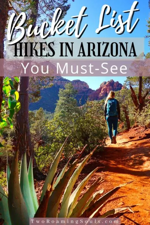
Arizona has some of the most stunning hikes in the United States. From the famous Havasu Falls & The Wave, to the legendary Grand Canyon, you are sure to have your mind blown while hiking in Arizona.

The best time to visit Arizona for hiking adventures is from Fall to Spring. And depending on the weather and elevation, summer and winter can also have some great climate for hiking.
Some of our all-time favorite hikes are located in Arizona, so let’s dive into the top 10 best hikes in Arizona ultimate guide.
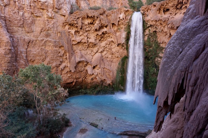
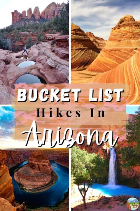
Havasu Falls:

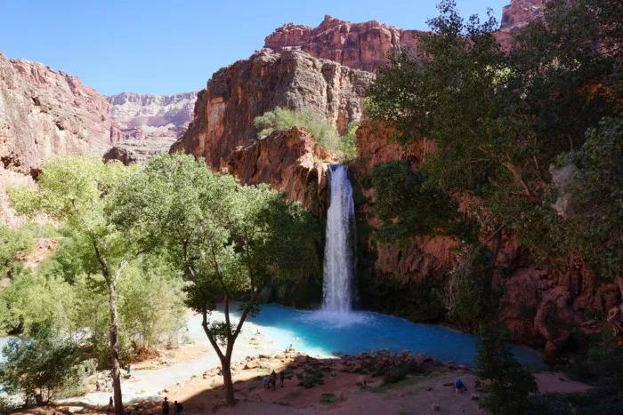
24 miles – 3,651 ft elevation
One of the most iconic hikes in the United States is Havasu Falls.
It is definitely suggested as a multi-day backpacking trip, but it can be done as an overnight if you are short on time. But day hiking is not allowed and would be extremely exhausting.
You need a permit to explore Havasu Falls which can be some of the hardest permits to get. The permit system is a lottery and they go on sale at 8am (Arizona time) on February 3 for everyone around the world. So you can imagine it is hard to snatch one as people travel all over the world to see this natural wonder.
The hardest part of the trail is the hike down into the canyon. It is suggested to go before the sun rises because it can be brutally hot hiking up or down the canyon wall.
The majority of the hike is along a wash and easy to follow.
You will then reach the town of Havasupai where you have to register with your permit.
Then, there are 5 primary waterfalls to explore: Fifty Foot Falls, Little Navajo Falls, Havasu Falls, Mooney Falls and Beaver Falls. These majestic aqua waterfalls are sure to take your breath away.
For more details on this best hike in Arizona check out our post: How To Plan A Trip To Havasu Falls | Everything You Need To Know
The Wave:
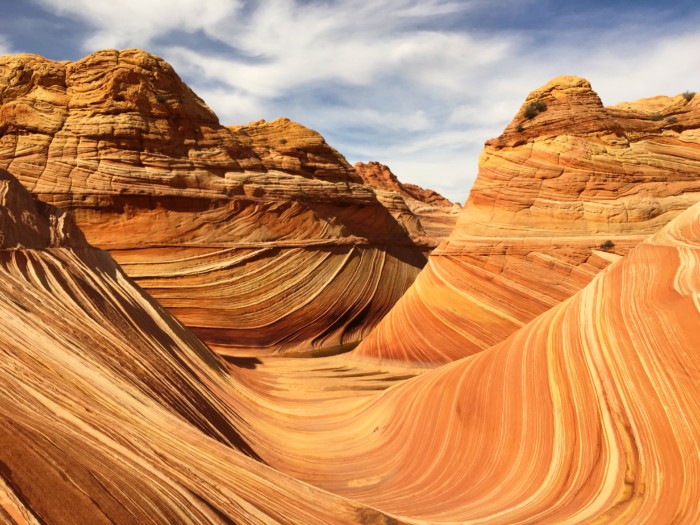

6.2 miles – 1,167 ft elevation
Another extremely popular hike in Arizona is The Wave. But there is a permit system in place, which can be very hard to get.
The permit system used to only allow 20 people on the trail, but they have since raised the permit amount to 64 people per day. The permit is via a lottery. You can try for a permit online in advance or try for a walk in permit.
If you receive a permit, the ranger will give you all the details you need for hiking the Wave.
Be prepared for this hike as it is exposed the whole way. Bring at least 1 gallon of water per person.
It is also suggested to bring a GPS as it can still be hard to find the Wave with the provided information from the rangers.
But once you do make it to the legendary rock formations of the wave, it is truly unique.
For more details on this best hike in Arizona check out our post: Hiking The Wave | Everything You Need To Know
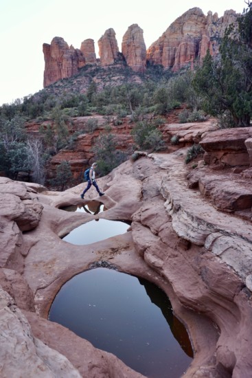
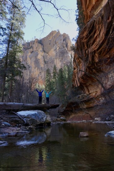
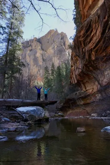
Soldiers Pass:
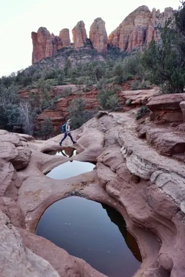
4.1 miles – 620 ft elevation
Soldier’s Pass is one of my favorite hikes in Sedona, AZ.
But to be completely honest, you can’t go wrong with any hike in Sedona, as it is one of the most stunning areas in Arizona.
Plus Jake and I had the pleasure of living there for a couple months so we got to explore much of the area. Check out our full review of vanlife in Sedona.
The main reason I like Solider’s Pass is that there are many different scenic stops along the way. There is Devil’s Kitchen, Seven Sacred Pools, Soldier’s Pass Cave, and the breathtaking views at the end.
You get a diverse feel for Sedona while hiking this trail.
If you are looking for other stunning hikes in Sedona, Arizona check out our post: 15 Best Breathtaking Hikes In Sedona, AZ
Aravaipa Canyon:

9.6 miles – 649 ft elevation
Aravaipa Canyon is a gem in Arizona. Jake and I love canyon hikes, and Aravaipa Canyon is one of the easiest ways to escape the crowds in Arizona.
You will need a permit for this hike, so be sure to plan ahead. They only allow 50 people in the canyon per day.
There are two ways to access this hike, which via the West or East Trailhead. In this guide, we will be talking about West Trailhead, because that is our experience.
From the beginning of the hike, it starts off as a challenge to find the right trail. You can hop in the water right away, but you can follow alongside the creek if you don’t want to get your feet wet right away. But nonetheless, getting your feet wet will be inevitable.
The canyon starts pretty wide but quickly begins to narrow with tall rocky walls.
The scenery in the canyon is beautiful with lush vegetation surrounding the river. This is in contrast to the arid desert land above the canyon.
In the fall, the colors in the canyon pop and add even extra beauty.
For more details on this best hike in Arizona check out our post: Arivaipa Canyon | A Stunning Canyon Hike In Arizona
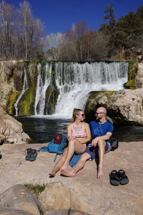
Fossil Creek (Bob Bear Trailhead):

8.3 miles – 1500 ft elevation
Fossil Creek is such a great spot in Arizona to cool off from the hot sun. But, with many signs along the trail it seems the hot summer sun can be very dangerous.
We visited Fossil Creek in late winter and it was almost the perfect temperature for a swim, so I can imagine in the summer the weather gets a bit too warm.
Permits are required between April and October via Recreation.gov.
But the hike can be done in a few different ways. You can either drive a long 4×4 road to the springs or hike down to the springs.
The magic of Fossil Creek is that over 30 million gallons of water flow out of the springs per day! These natural springs feed enough water to keep the river flowing year-round.
And considering Arizona’s generally dry and arid climate, this perennial stream is even more special. The fertile valley floor is in surprising contrast with the surrounding desert landscape.
For more details on this best hike in Arizona check out our post: Fossil Creek Wilderness | A Natural River Oasis In Arizona
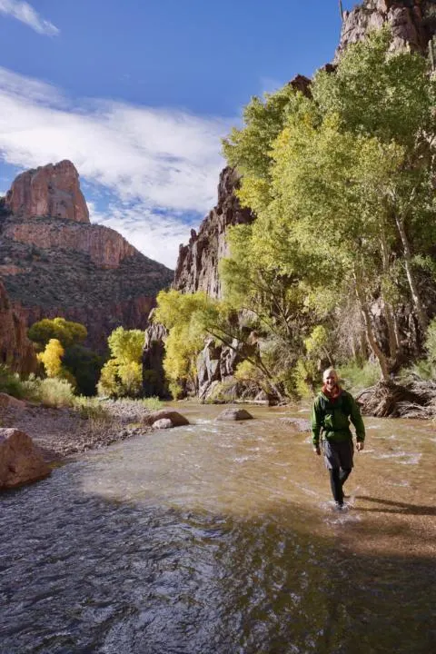
West Fork:
7.2 miles – 820 ft elevation
Another one of the best hikes in Arizona is West Fork. The hike is located right outside Sedona in Oak Creek Canyon and is one of the most enchanting and rewarding hikes.
The area is said to be one of the energy vortexes that Sedona is famous for.
The trail winds up the West Fork of Oak Creek, surrounding you with tall canyon walls. You will come across many spots along the hike that will take your breath away.
The canyon is bursting with life in the river and the surrounding forests along its banks.
The hike is open year round, and the shade of the canyon is a great way to escape the Arizona heat.
There are a few river crossings, but rocks are strategically placed so you usually don’t have to get your feet wet.
Jake and I visited in the winter which added a unique feel inside the canyon. But that also meant many of the trees weren’t in bloom which I think adds a great vibrant feel to the canyon.
You will want to head to the parking lot before 8 am because it fills up quickly.
For more details on this best hike in Arizona check out our post: West Fork Trail In Sedona, AZ | Ultimate Hiker’s guide
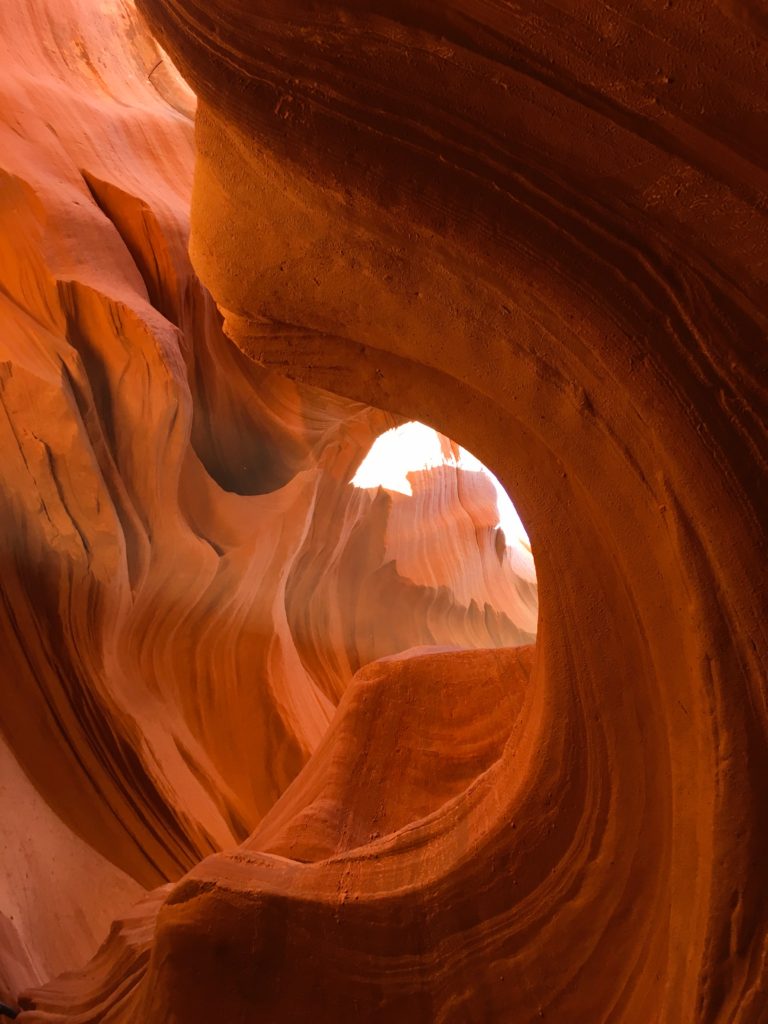
Antelope Canyon:

.8 – 1.1 miles – 100 – 300 ft elevation
Another famous hike/ tourist attraction near Page, AZ is Antelope Canyon. And it is easily one of the best hikes in Arizona. You will need to book a tour in advance to see this legendary spot.
There are two different sections you can tour: Upper Antelope Canyon and Lower Antelope Canyon. They both offer epic experiences.
Upper Antelope Canyon is a shorter tour, out and back, but better for photography.
Lower Antelope Canyon is a longer tour and a loop hike. Personally, we loved Lower Antelope Canyon and thought the photography opportunities were nothing short of amazing.
While on either hike, be ready to be impressed by the wavy sandstone that water created over many years.
The slot canyon encompasses you in breathtaking narrow passages.
For help choosing between upper and lower Antelope Canyon, read our post below.
For more details on this best hike in Arizona check out our post: How To Choose Between Upper and Lower Antelope Canyon | Epic Guide
Bright Angel Point

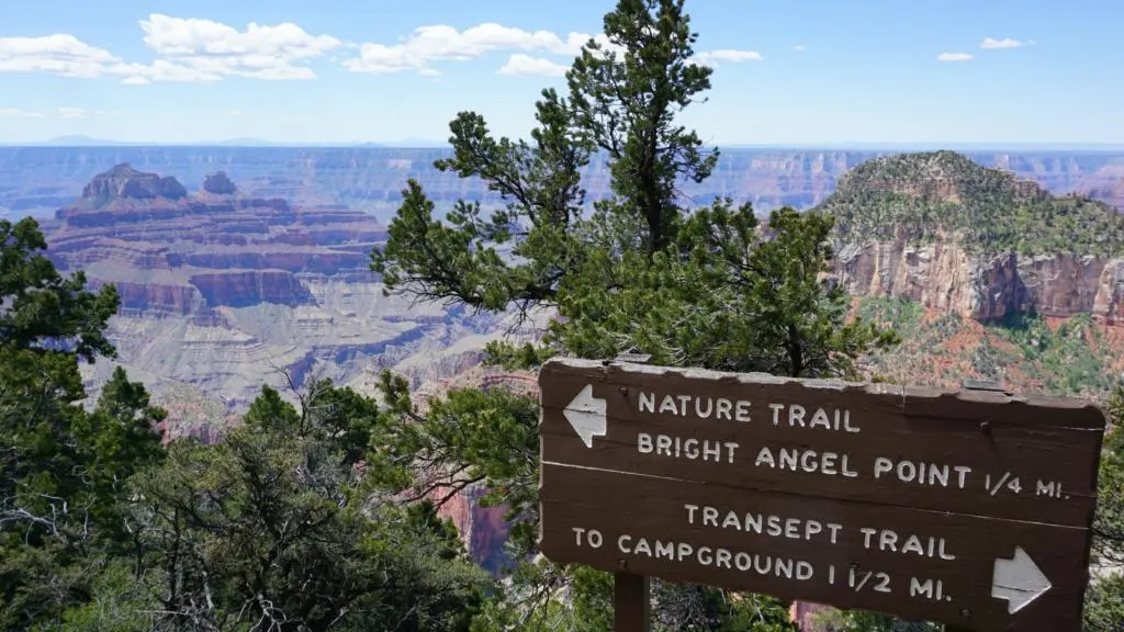
.9 miles – 144 ft elevation
What is Arizona best known for? The Grand Canyon… So no trip to Arizona would be complete without visiting the Grand Canyon.
The best part about the Grand Canyon is there are endless viewpoints along the road that are easy to walk to.
But I would say one of the best views in the park is at Bright Angel Point. And if you want to make the hike hard, many trails combine to extend the hike further along the rim.
A good add-on hike is Bright Angel Trail itself. If you pair it with this hike, you are sure to walk away from the Grand Canyon with an appreciation of the immense scale of this American treasure.
The hike to Bright Angel Point is along a well-maintained path and leads you to one of the most epic views in the park. So be sure to add this to your bucket list when visiting Arizona.
Horseshoe Bend:
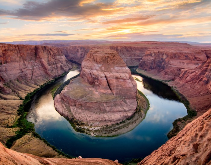
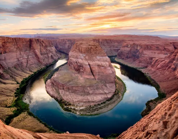
1.5 miles – 242 ft elevation
I’m sure you’ve seen Horseshoe Bend in a picture or two on social media. It has definitely become a popular stop for tourists visiting Page, AZ.
There is a fee for the hike that you pay at the entrance booth. Our suggestion would be to try and get on the hike early to not only beat the heat, but also beat the crowds. Or sunrise and sunset tend to be the best time for photos.
The hike is moderate and relatively short, so people do come and go pretty often.
As you would expect, the view at the end is breathtaking as you can walk right up to the rim and see 1000’s of feet below.
Which brings me to say, be super CAREFUL when visiting this place. It will be busy, so give people their space and only walk as close to the edge as you are comfortable.
But Horseshoe Bend is totally worth the visit if you are adventuring in Arizona.
For more details on this best hike in Arizona check out our post: Horseshoe Bend | Everything You Need To know
White Pocket:
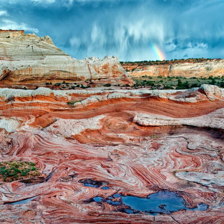

1.5 miles – 160 ft elevation
White Pocket is not the easiest trailhead to get to as it requires 4×4 to venture through deep sand.
But if you are looking to get remote and away from civilization, this is your spot.
It’s also a great alternative to The Wave Hike which we mentioned earlier in the post.
White Pocket is a beautiful place where you can roam around to enjoy red and white swirled sandstone. The stunning colors and unique patterns in the rock are other-worldly.
If you want to follow a GPS loop hike, refer to AllTrails.
Takeaway | Top 10 Best Hikes In Arizona | Ultimate Guide
Arizona is one great place for epic hiking adventures. Jake and I have absolutely loved exploring this state and are lucky to have experienced the natural beauty here.
These just happen to be our opinion of the best hikes in Arizona.
So we hope you enjoy you hiking adventures and get to explore Arizona to the fullest on these epic locations.
Help Us Share Top 10 Best Hikes In Arizona | Ultimate Guide On Pinterest:


How Much Does It Cost To Rent A Camper Van - tworoamingsouls
Thursday 6th of April 2023
[…] The Ultimate Arizona Road Trip Itinerary […]